Chester, California
Getting to Cedar Lodge
We are at 1487 County Road 324, where Highway 36 meets Highway 89, about three miles west of Chester at the north end of Lake Almanor. Every distance on this page carries the source it came from, and the ones we could not source are named rather than guessed.
- Highway 36 at the Highway 89 junction
- About three miles west of Chester
- Open all year
- Gravel parking on the property
How far things are
Five numbers we can stand behind, each with where it came from and when we checked it.
- Lake Almanor About half a mile to a mile Property record, 19 September 2026
- Chester town centre About three miles east of us Local race coverage and the race organiser's own directions, read 22 September 2026
- The Highway 36 crossing of the Pacific Crest Trail About eight miles Two independent hiker sources, read 22 September 2026
- Warner Valley and Drakesbad, Lassen Volcanic National Park Roughly 17 miles from Chester Plumas County tourism, read 22 September 2026. The Park Service describes it as a 13 mile road from the highway
- Juniper Lake, Lassen Volcanic National Park 13 miles of road from the highway, partly unpaved National Park Service, Getting Around, read 22 September 2026
What is not on this list: Reno, Sacramento, Chico, Redding, and the Lassen Southwest Entrance. We have no sourced drive time for any of them, so we print none. Put the address into your map app and it will give you a live number for the day you are actually driving.
By road
Highway 36 runs east and west past our door, and Highway 89 meets it here. Whichever direction you come from, the last few miles are on one of those two roads, and the turn in is County Road 324.
From the west, Highway 36 climbs over the Lassen summit and past Child's Meadows before it drops toward Chester. From the east, the twenty miles between Susanville and Chester is the curved part. If you ride, know that the celebrated section of Highway 36 is west of Red Bluff rather than the stretch beside us. We would rather say that than have you find out.
Flying in, the airports people ask about are Reno-Tahoe International, Redding Municipal and Chico. We have no sourced drive time to any of them. Whichever you use, you will need a car: there is no bus or train connection here worth sending you to.
Chester, California, at the junction of Highway 36 and Highway 89, in Plumas County. Outline simplified, not to survey accuracy. The four cities are shown for scale, not as sourced distances.
The two ways into Lassen from our side
Warner Valley and Juniper Lake go in from our side of town. Both are worth the drive and both will punish a car you have not thought about.
Warner Valley and Drakesbad are roughly 17 miles from Chester by Plumas County's figure. The Park Service describes the access this way:
A 13-mile, partly-unpaved road is used to access the Warner Valley area. The last three miles is dirt road with steep sections.
Trailers are not recommended on it.
Juniper Lake is 13 miles of partly unpaved road, and the Park Service says the last six miles is rough dirt road with steep sections. It was closed during 2026 while damage was repaired, so check the park's own page before you set out rather than trusting this one.
Both roads are not maintained in winter, and the Park Service advises against vehicle travel when snow covers them, approximately November to June. Butte Lake, on the far side, closes approximately November to April.
The Southwest Entrance is a different drive, west on Highway 36. We do not have a sourced distance or drive time for it and we are not going to invent one.
Winter, and the road through the park
The part of the year most lodging pages quietly leave out.
Lassen Volcanic National Park is open 24 hours a day, 365 days a year. What closes is the road through it. The Park Service says that road typically closes for the season in mid to late November, names December through March as the winter season, and limits vehicle access to the Kohm Yah-mah-nee Visitor Center at the southwest entrance and the Loomis Plaza and Manzanita Lake parking area at the northwest entrance.
When the road has opened, recently:
- 29 May 2020Park road fully open
- 17 May 2021Park road fully open
- 3 Jun 2022Park road fully open
- 1 Jul 2023Park road fully open
- 20 Jun 2024Park road fully open
- 27 Jun 2025Park road fully open
The Park Service states plainly that it has no established date for the full opening and that it may come as late as early July. Anyone selling you a spring park visit on a fixed date is guessing.
Highway 36 and Highway 89 are Caltrans roads, and chain control is a normal winter fact of life here. We do not publish a road report, a snow report or a live road status, and we are not going to tell you a road is clear. Caltrans publishes California road conditions on QuickMap, and the Park Service publishes what is open inside the park on its own site. Check both on the morning you drive.
The burned ridge
The 2021 Dixie Fire came through this valley. It burned roughly 960,000 acres, destroyed more than 75 percent of the structures in Greenville, roughly 25 miles from Chester, and burned a large share of Lassen Volcanic National Park.
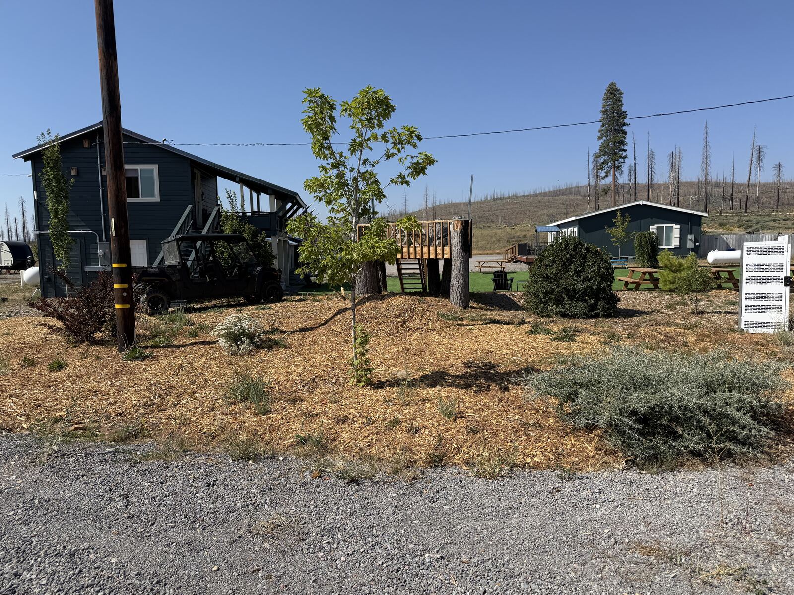
You will see standing burned trees on the ridge behind us, and burn scar on the drive in from more than one direction. The valley is in the middle of a long recovery and the work is visible.
We put this on the page on purpose. Arriving to a burned ridgeline nobody warned you about is a worse surprise than reading about it now.
When you arrive
Turn onto County Road 324 off Highway 36. The house is on the left with its covered porch, the motel row is on the right under its metal roof, and the parking is the gravel between them.
Check in is after 4 PM. Check out is 10 AM from a room or the house and noon from an RV site. Quiet hours run 10 PM to 6 AM, there is no smoking, the minimum stay is one night, and up to two dogs of 70 lbs or less are $20 a night. All six are on rates and policies.
Accessibility has never been measured at this property. Nobody has taken a tape measure to a doorway, a bathroom, a parking bay or the route between them, so we are not going to tell you that a room, a site or a path is accessible. If you have specific access needs, email us before you book, tell us exactly what you need to know, and we will go and look at that thing and tell you what we find.
Email daniel@youreasypark.com. We answer within one business day.
Where you sleep
Motel rooms from $125 a night, the three bedroom house from $225, RV sites from $60, each plus Plumas County tax. No fee is added between the price you see and the price you pay.
First bookable night is 30 September 2026.
Sources, and when we checked them
Last checked 23 September 2026.
- Road specifications and the seasonal closure wording for Warner Valley, Juniper Lake and Butte Lake: National Park Service, Getting Around, Lassen Volcanic National Park, read 22 September 2026.
- Park hours, the winter season, and the limits on winter vehicle access: National Park Service, Operating Hours and Seasons, read 22 September 2026.
- Opening dates for the park road, 2020 to 2025, and the statement that there is no established opening date: National Park Service, winter road closures and spring clearing, read 22 and 23 September 2026.
- The Juniper Lake road closure during 2026: Active NorCal, read 22 September 2026.
- Roughly 17 miles from Chester to Warner Valley: Plumas County tourism, read 22 September 2026.
- About eight miles to the Highway 36 crossing of the Pacific Crest Trail: two independent hiker sources, read 22 September 2026.
- About three miles west of Chester: Sierra Nevada Dog Drivers race directions and local coverage of the same race, read 22 September 2026.
- Highway 36 for riders, and which section is the celebrated one: Pashnit, read 22 September 2026.
- Dixie Fire acreage, the loss in Greenville and the scale of the rebuild: Sierra Nevada Conservancy and California environmental review filings, read 22 September 2026. The share of the national park burned is from secondary coverage of Park Service statements rather than from the Park Service directly.
- About half a mile to a mile to Lake Almanor: our own property record, 19 September 2026.
- California road conditions and chain control: Caltrans QuickMap. We link it, we do not mirror it.